- difficulty
Strenuous
-
Start in
Taplejung
-
end in
Khamdime
-
group size
10
-
max altitude
5143 m / 16873 ft (Pangpema)
-
Accommodation
Tea House
-
Best Season
Spring (March-May)
Overview
Introduction to Kanchenjunga Circuit Trek
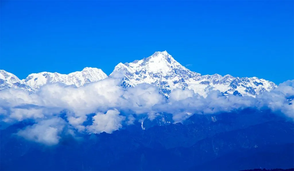
Kanchenjunga is located on the extreme east of Nepal, close to the boundary with Sikkim, a small Himalayan state in northeastern India.
Kanchenjunga was regarded as the world’s highest peak until the middle of the 1800s. Trekkers were not allowed in this area until the middle of the 1980s. The Kanchenjunga Conservation Area now protects the area, and a special trekking permission is needed.
Despite these limitations, the area’s stunning and distinctive flora and animals are preserved in perfect form today.
Regarding the mountains themselves, there are four subsidiary summits that are higher than 8,000 meters in addition to Kanchenjunga’s main peak. The most significant of them is Kanchenjunga West, also called Yalung Kang (8,505 meters).
About twenty peaks higher than 7,000 meters can also be found in this region; the tallest are Kambachen (7,903 meters), Janu (7,710 meters), Jongsong (7,483 meters), Kabru (7,353 meters), Tent Peak (7,365 meters), and the Twins (7,350 meters). Rnrn There are also many summits that are higher than 6,000 meters. There are five main glacier systems among this striking group of hills.
The Kanchenjunga and Yalung glaciers feed into Nepal’s powerful Tamor River to the west, while Zumu, Talung, and Rathong flow into Sikkim. This just serves to highlight how trekking in Kanchenjunga is an amazing experience as hikers immerse themselves in the
The Kanchenjunga and Yalung glaciers feed into Nepal’s powerful Tamor River to the west, while Zumu, Talung, and Rathong flow into Sikkim. This just serves to highlight how hiking in Kanchenjunga is an incredible experience that allows hikers to into the heart of the isolated, less-traveled Himalayan mountains and valleys.
More teahouses are developing along the Great Himalayan Trail as a result of the recent update to the hiking map, which promotes tourism in this and other isolated places. Although the local communities benefit from this, now would be a wonderful time to visit Kanchenjunga before more hikers “discover” the region.
Trip highlights
Discover Nepal’s less-traveled eastern highland areas. Arrow Right Primary
Stroll by the area’s well-known glacial lakes
Fantastic experience exploring the variety of plants and animals
After your exhausting walks, meditate in the monasteries of Ramtang and Oktang.
Enjoy yourself immensely on the enormous peaks’ lap.
itinerary
- day 1
Kathmandu to Bhadrapur (Flight) to Fikkal/Kanyam (Drive)
✈️ Travel: Flight (45–60 minutes) or 🚌 Bus (3–4 hours)
🏨 Accommodation: Hotel
🍽️ Meals: Lunch & Dinner
📍 Overnight: Fikkal / Kanyam
Our tour will pick you up from your hotel after breakfast and take you to the airport. The quick flight to Bhadrapur passes across some of Nepal’s most iconic mountains as well as the Kathmandu Valley and surrounding hills. A complimentary mountain flight! We will go by car to Fikkal/Kanyam, the center of the nation’s tea plantation region, after arriving in Bhadrapur.
- day 2
Fikkal/Kanyam to Taplejung (Drive)
🏔️ Altitude: 1,820 m / 5,971 ft
🚌 Drive Time: 4–5 hours
🏨 Accommodation: Hotel
🍽️ Meals: Breakfast, Lunch & Dinner
📍 Overnight: Taplejung
The following day, we go northeast to Taplejung, the district office and the Kanchenjunga Circuit Trek’s official starting site. The road is frequently narrow, has a mixture of gravel and paved surfaces, and is vulnerable to landslides during the monsoon.
The route travels through villages that grow cardamom, terraced farmlands, and undulating hills. It gives you a sense of how isolated trekking is in eastern Nepal, despite being lengthy and exhausting.
Compared to e
arlier stops, Taplejung has more advanced infrastructure. There are hotels, stores, hospitals, and even an ATM-equipped bank. We ought to take advantage of this chance to purchase trekking poles, SIM cards, snacks, and batteries.
The majority of the cultural presence is Limbu, a
nd you may see intricately carved wooden houses and traditional temples. Taplejung’s altitude is less than 2,000 meters, thus acclimatization is still relatively low, but Himalayan landscapes is beginning to emerge.
- day 3
Taplejung to Sekathum
🏔️ Altitude: 1,650 m / 5,413 ft
🥾 Trek Time: 5–6 hours
🛖 Accommodation: Tea House
🍽️ Meals: Breakfast, Lunch & Dinner
📍 Overnight: Sekathum
The trip officially begins on day three. The trail follows Ghunsa Khola upstream after descending from Taplejung to the Tamor River Valley.
There are stone steps, severe descents, and a few little ascents along the path. It passes through rural communities with farmed terraces of corn and millet as well as subtropical woodlands. Limbu and Rai villagers are seen farming or carrying loads in bamboo baskets.
Additionally, you enter the Kanchenjunga Conservation Area on this day; hiking permits are required in this protected area. This stretch is relatively difficult yet beautiful, with trekkers walking along rivers and cliffs and crossing multiple suspension bridges. Particularly in the spring or after rain, there may be a lot of humidity and muddy areas of the trail.
Sekathum is a small riverbank village with 2–3 teahouses with limited facilities: twin-sharing rooms with thin beds, plain Nepali dishes (dal bhat, noodles), and boiled water. There can be a shortage of electricity and a spotty or nonexistent cell signal.
- day 4
Sekathum to Amjilosa
🏔️ Altitude: 2,510 m / 8,235 ft
🥾 Trek Time: 6–7 hours
🛖 Accommodation: Tea House
🍽️ Meals: Breakfast, Lunch & Dinner
📍 Overnight: Amjilosa
One of the toughest climbs in the early stages of the journey is on Day 4. Following Ghunsa Khola, the trail ascends through dense rhododendron and bamboo forests. Numerous suspension bridges and tight cliffside sections on the walk necessitate cautious foot placement. Particularly for novice hikers or those with larger packs, this is one of the more physically taxing days.
This woodland zone is home to animals including Himalayan monals, red pandas, and langurs, but sightings are few. There aren’t many human settlements, although you can come across Tibetan yak herders or makeshift houses used for grazing. Trekking at higher elevations begins at this point, and early symptoms of altitude sickness, such as exhaustion and dyspnea, may manifest.
- day 5
Amjilosa to Gyabla
🏔️ Altitude: 2,730 m / 8,956 ft
🥾 Trek Time: 3–4 hours
🛖 Accommodation: Tea House
🍽️ Meals: Breakfast, Lunch & Dinner
📍 Overnight: Gyabla
Following breakfast, we go through various pine, bamboo, rhododendron, and oak forests. We see that the people and communities are starting to resemble Tibet.
Along with a wide variety of birds, we also observe yaks, sheep, and goats on the walk. Following lunch, the trail ascends through thick forest and across a wooden bridge to reach Gyabla, where we spend the night.
- day 6
Gyabla to Ghunsa
🏔️ Altitude: 3,595 m / 11,794 ft
🥾 Trek Time: 3–4 hours
🛖 Accommodation: Tea House
🍽️ Meals: Breakfast, Lunch & Dinner
📍 Overnight: Ghunsa
The road now passes through woodlands and Phale Village, a settlement for Tibetan refugees established decades ago when Tibetans began escaping China’s communist government.
It’s a winter settlement village now. We have time to go to the village and buy some handicrafts. We travel to Ghunsa, the biggest village in the region, which has a Kanchenjunga Conservation Office, a police station, and a health post. This location offers internet and phone services.
- day 7
Acclimatization Day
🏔️ Altitude: 3,595 m / 11,794 ft
🚶 Activity: Short acclimatization hikes
🛖 Accommodation: Tea House
🍽️ Meals: Breakfast, Lunch & Dinner
📍 Overnight: Ghunsa
Now that we are at a higher altitude, our goal is to reach even higher! Thus, we seize the chance to unwind and get used to Ghunsa. There’s a ridge to climb and a monastery to discover.
The vistas of Jannu Peak from the ridge make the five-hour round-trip journey worthwhile. We will bring a packed lunch if you want to ascend the ridge, which we advise since it helps acclimate our bodies.
- day 8
Ghunsa to Kambachen
🏔️ Altitude: 4,100 m / 13,451 ft
🥾 Trek Time: 3–4 hours
🛖 Accommodation: Tea House
🍽️ Meals: Breakfast, Lunch & Dinner
📍 Overnight: Kambachen
Today, the skyline is dominated by views of the Jannu Himal. We reach a verdant glacier valley after taking a leisurely ascending route. We might be fortunate enough to see snow leopards and blue sheep here. We exercise extra caution in a landslide-prone location where the trail goes past a waterfall.
- day 9
Acclimatization Day
🏔️ Altitude: 4,100 m / 13,451 ft
🚶 Trek Time: 2 hours (optional hikes)
🛖 Accommodation: Tea House
🍽️ Meals: Breakfast, Lunch & Dinner
📍 Overnight: Kambachen
Once more, we seize the opportunity to prepare for our excursion to the North Base Camp and to acclimate our bodies to the altitude. Today, we can ascend a different ridge that offers breathtaking views of Kanchenjunga.
- day 10
Kambachen to Lhonak
🏔️ Altitude: 4,785 m / 15,698 ft
🥾 Trek Time: 3–4 hours
🛖 Accommodation: Tea House
🍽️ Meals: Breakfast, Lunch & Dinner
📍 Overnight: Lhonak
Today, the trail mostly crosses the Kanchenjunga Glacier’s moraine. There are breathtaking views on both sides of us as we walk uphill over big boulders.
We also keep a look out for this uncommon animal because we are deep in Snow Leopard country! Although there are no towns along the road, there are summer yak farms in this area as well.
- day 11
Day Trip to Kanchenjunga North Base Camp
🏔️ Altitude: 5,143 m / 16,873 ft (Base Camp)
🥾 Trek Time: ~8 hours
🛖 Accommodation: Tea House
🍽️ Meals: Breakfast, Lunch & Dinner
📍 Overnight: Lhonak
At an elevation of roughly 5,143 meters (16,873 feet), Kanchenjunga North Base Camp, also called Pangpema, is the last stop on the Kanchenjunga North Trek. Along with other majestic summits like Tent Peak and Chang Himal, it provides stunning views of Kanchenjunga (8,586 meters), the third-highest mountain in the world. One of the most daring treks in Nepal, the road to the base camp passes through isolated communities, deep forests, high-altitude meadows, and glacier moraines.
Trekkers typically stay in Lhonak and hike to the base camp as a day trip because Pangpema lacks tea houses due to its remote and untamed position. The location is surrounded by striking glaciers and ice walls, creating a stark yet breathtaking scene.
- day 12
Lhonak to Ghunsa
🏔️ Altitude: 3,595 m / 11,794 ft
🥾 Trek Time: 7 hours
🛖 Accommodation: Tea House
🍽️ Meals: Breakfast, Lunch & Dinner
📍 Overnight: Ghunsa
On Day 13, we retrace our tracks over breathtaking alpine terrain as we descend from Lhonak (5,065 meters/16,617 feet) to Ghunsa (3,475 meters/11,401 feet). The trail continues to show the north face of Kanchenjunga as it passes Ramtang and Kambachen. Even while the descent lessens the strain on your lungs, there are still rocky areas that call for cautious footing. The experience is enhanced by the frequent sighting of wildlife in this isolated valley, including blue sheep and traces of snow leopards.
The scenery softens into verdant forest as we descend about 1,600 meters (more than 5,200 feet) in altitude. We reach Ghunsa, a friendly Sherpa community with wooden homes, prayer flags, and a peaceful monastery, by late afternoon.
- day 13
Ghunsa to Sele Le
🏔️ Altitude: 4,390 m / 14,402 ft
🥾 Trek Time: 5 hours
🛖 Accommodation: Tea House
🍽️ Meals: Breakfast, Lunch & Dinner
📍 Overnight: Sele Le
Today, the trail passes through a forest and along a grassy ridge where we can see Mt. Makalu in the distance along with the settlements of Ghunsa and Phole.
- day 14
Sele Le to Cheram
🏔️ Altitude: 3,870 m / 12,696 ft
🥾 Trek Time: 7–8 hours
🛖 Accommodation: Tea House
🍽️ Meals: Breakfast, Lunch & Dinner
📍 Overnight: Cheram
This morning, we set off early in the direction of the Kanchenjunga South Base Camp. The trail leads us up a ridge to Sinelapche La Pass (4,830m) after crossing the Sinion La Pass (4,450m).
The views of Mount Kanchenjunga and its valley are breathtaking from this location. The only settlement on this road is Cheram, which we reach by descending along a narrow track. Here, we spend the night.
- day 15
Day Trip to Kanchenjunga South Base Camp to Ramche
🏔️ Altitude: 4,580 m / 15,026 ft
🥾 Trek Time: 6 hours
🛖 Accommodation: Tea House
🍽️ Meals: Breakfast, Lunch & Dinner
📍 Overnight: Ramche
We hike to Ramche today, stop for lunch, and then continue trekking for around forty minutes to get to Kanchenjunga South Base Camp. Tibetan prayer flags encircle the Base Camp, which is situated just on the glacier’s edge. To spend the night at Cheram, we head back the way we came.
- day 16
Ramche to Torongding
🏔️ Altitude: 2,080 m / 6,824 ft
🥾 Trek Time: 4 hours
🛖 Accommodation: Tea House
🍽️ Meals: Breakfast, Lunch & Dinner
📍 Overnight: Torongding
From the alpine zone to the temperate woodland, the trail declines sharply. After retracing a portion of the track past Cheram, you turn west into thick pine and rhododendron trees. Wildlife sightings are possible in this area, which is part of the Kanchenjunga Conservation Area. Keep an eye out for red pandas, barking deer, and Himalayan monals.
Steep climbs, slick switchbacks, and sporadic landslides are features of the trail. To lessen the strain on your knees, use trekking poles. With just two teahouses and few conveniences, Torongding is a peaceful community. There is no internet, and charging gadgets could be more expensive (between Rs. 300 and Rs. 500 per device). Natural springs provide water, but it needs to be boiled or cleansed. In addition to improving hunger and sleep quality, this descent aids hikers in acclimating to lower altitudes.
- day 17
Torongding to Rani Pul
🏔️ Altitude: 1,430 m / 4,690 ft
🥾 Trek Time: 6–7 hours
🛖 Accommodation: Tea House
🍽️ Meals: Breakfast, Lunch & Dinner
📍 Overnight: Khebang
This day is spent going continuously downwards in a verdant, humid setting. The walk passes through subtropical forests, cardamom plantations, and bamboo groves. Wear leech socks or gaiters because leeches are frequent in this area, especially after rain.
We will go via communities in Chhetri and Limbu, where terrace farming and traditional mud homes predominate. Although basic Nepali is understood, the majority of the language spoken is Limbu. Homes and animals like buffalo, goats, and chicks frequently employ solar panels. By the afternoon, we will arrive in Rani Pul, a tiny roadside community with jeep access and a few roadside restaurants and guesthouses.
- day 18
Rani Pul to Taplejung (Drive)
🏔️ Altitude: 1,820 m / 5,971 ft
🥾 Trek Time: 4 hours
🛖 Accommodation: Tea House
🍽️ Meals: Breakfast, Lunch & Dinner
📍 Overnight: Khamdime
We return to Taplejung via a local 4WD jeep from Rani Pul, typically a Mahindra Bolero or Tata Sumo. The drive climbs through farmland and verdant slopes while following the Kabeli River. The primary source of income for the local residents in this area is the production of cardamom. During the monsoon season (June to September), roads may be closed, therefore schedule flexibility is essential.
Hotels with private rooms, electricity, Wi-Fi, and hot showers are available in Taplejung; these amenities were unavailable in earlier trekking communities. Local stores, pharmacies, and ATMs are also present. The majority of Kanchenjunga trek itineraries officially terminate at Taplejung, the region’s commercial and administrative hub.
- day 19
Bhadrapur to Kathmandu (Flight)
🏔️ Altitude: 1,300 m / 4,265 ft
✈️ Flight Time: 50 minutes
🏨 Accommodation: Hotel
🍽️ Meals: Breakfast & Lunch
📍 Overnight: Kathmandu
You return to Nepal’s lowlands after your lengthy drive. The route travels via the cities of Phidim, Ilam, and Fikkal, which are well-known for their commercial markets and tea plantations. The terrain will shift from the slopes of the Himalayas to level plains. After Phidim, the road is largely black-topped, however there are some uneven sections. It would be late afternoon or evening when you arrive in Bhadrapur.
Not satisfied with this itinerary?
Make your own.Price Included
19 nights accommodation in mountain tea houses
✅ Kathmandu – Bhadrapur – Kathmandu flights
✅ Local bus transfers: Bhadrapur – Taplejung & Khamdime – Bhadrapur
✅ Professional trekking guide for 19 days
✅ -end=”433″>Kanchenjunga Conservation Area Permit (KCAP)
✅ Restricted Area Permit (RAP)
✅ Meals during the trek:
✅ 19 × Breakfast
✅ 18 × Lunch
✅ 19 × Dinner
Write a review
Quick enquiry
Still confused?
Talk to our expert.

Kumar Dahal

