- difficulty
Strenuous
- Trip Style
Group
- Start in
Bhadrapur
- end in
Tumlingtar
- group size
10
- max altitude
5070 m / 16634 ft
- Best Season
spring (March to May) and autumn (September to November)
Overview
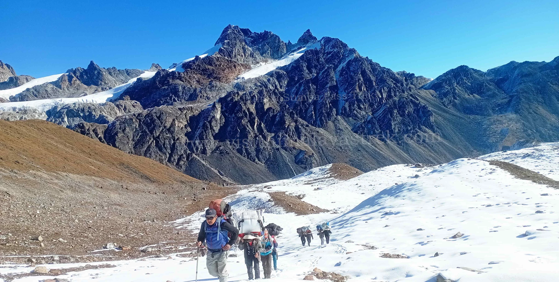
Lumba Sumba Pass Trek is one of Nepal’s most remote and spectacular high-altitude trekking routes, connecting the Kanchenjunga Conservation Area with the Makalu Barun National Park in the eastern Himalayas. This challenging 18-22 day camping trek traverses the rarely explored Lumba Sumba Pass at 5,177 meters (16,985 feet), offering adventurous trekkers an authentic wilderness experience far from crowded trails. Opened only in 2012, this Trek region follows a section of the legendary Great Himalayan Trail (GHT), weaving through diverse landscapes from subtropical forests to high alpine zones while showcasing breathtaking panoramic views of the world’s third and fifth highest peaks—Mount Kanchenjunga and Mount Makalu. Whether you’re seeking an off-the-beaten-path Himalayan adventure with rich cultural encounters, dramatic mountain scenery, and encounters with endangered wildlife like snow leopards and red pandas, this Trek region promises an unforgettable journey through one of the Himalayas’ last truly pristine destinations.
- \nday\n1
Arrival in Kathmandu
- Arrival at the Tribhuvan International Airport.
- Our representative will greet you with warm regards and escort you to the hotel.
- Rest of the day is free for making the preparations of the trek that starts the following day.
- Overnight.
- \nday\n2
Kathmandu to Bhadrapur (Flight) to Ilam (Drive)
- \nday\n3
Bhadrapur to Taplejung (Drive)
Taplejung – 1820 m / 5971 ft – 9 hrs
- 🕒 Drive duration: 6 hours
- 🏡 Accommodation: Hotel
- 🍽️ Meals: Breakfast, Lunch and Dinner
- 📍 Overnight: Taplejung Hotel
Today is a long day on the road as you travel to Taplejung via switchback, dusty, and bumpy roads. On the route, there will be stops for lunch and tea.
When you get to Taplejung, your camping crew will arrive to get the equipment your guide brought from Kathmandu. They start by preparing dinner for you and setting up the campground.
- \nday\n4
Taplejung to Chirwa
Chirwa – 1270 m / 4166 ft – 6 hrs
- 🕒 Trek duration: 6 hours
- 🏡 Accommodation: Tea House
- 🍽️ Meals included: Breakfast, Lunch, and Dinner
- 📍 Overnight stay: Chirwa (Camping)
A day filled with firsts! The first day of serious hiking follows your first breakfast at the campsite! You will probably encounter other hikers over the next few days since you are traveling to Chirwa today, which is also included in the Kanchenjunga Base Camp Trek.
Today, you will go through meadows and deep woodlands with some steep inclines. Additionally, you will traverse the Tamor River on a suspension bridge.
- \nday\n5
Chirwa to Lelep" }, { "@context": "http://schema.org", "@type": "Article", "headline": "Lumba Sumba Pass Trek - 20 Days", "articleBody": "day\n6
Lelep To Illa Danda
Illa Danda – 2051 m / 6729 ft – 9 hrs
🕒 Trek duration: 9 hours
⛺ Accommodation: Camping
🍽️ Meals: Breakfast, Lunch, and Dinner
📍 Overnight: Illa Danda Camping
The Kanchenjunga Conservation Area is home to numerous types of birds, so you should keep a watch out for them today. You will travel through thick woodlands that may conceal some of the local wildlife, like langur monkeys and musk deer. The rarer creatures can be added to this list at greater elevations.
You can spend some time at the monastery after ascending uphill and over a suspension bridge before descending to Gowatar hamlet. There is a massive 100-meter (328-foot) waterfall not far from the town. After there, there’s a quick climb to Illa Danda, which offers breathtaking views of the Alps.
Illa Danda To Selep Kharka
Selep Kharka – 2525 m / 8284 ft – 9 hrs
🕒 Trek duration: 9 hours
⛺ Accommodation: Camping
🍽️ Meals: Breakfast, Lunch, and Dinner
📍 Overnight: Selep Kharka Camping
Today, after crossing a suspension bridge, more meadows and grazing pastures—possibly with sheep and yaks on them—become visible as the dense trees slightly recede. There are breathtaking vistas of the mountains as the trail climbs.
In reality, your campground for tonight is one of these high-altitude meadows with breathtaking views of the mountains.
Selep Kharka To Olangchung Gola
Olangchung Gola – 3208 m / 10524 ft – 7 hrs
🕒 Trek duration: 7 hours
⛺ Accommodation: Camping
🍽️ Meals: Breakfast, Lunch, and Dinner
📍 Overnight: Olangchung Gola Camping
As the altitude starts to rise today, the trekking is starting to become a little more strenuous. Enjoy the hike as you bridge the Tamor River once more and pass through more meadows and pastures because you have had plenty of time to get used to it. Additionally, you will hike through rhododendron forests, which are breathtaking in the spring when they blossom.
Olangchung Gola is a high-altitude meadow that offers breathtaking views of the Kanchenjunga Massif and other snow-capped peaks. You will spend the night camping here and take in the splendor of the surrounding mountains.
Acclimatization Day
Olangchung Gola – 3208 m / 10524 ft – 2 hrs
🍽️ Meals: Breakfast, Lunch, and Dinner
📍 Overnight: Olangchung Gola Camping
Today is an acclimatization day, so get ready for the high altitude that lies ahead.
Olangchung Gola is home to a monastery that is said to be more than 400 years old. You can take some time to explore it and Olangchung Gola, a Sherpa settlement.
If not, this is an opportunity to unwind, rest, and consider the future.
Olangchung Gola To Upper Langmale
Upper Langmale – 3893 m / 12772 ft – 7 hrs
🕒 Trek duration: 7 hours
⛺ Accommodation: Camping
🍽️ Meals: Breakfast, Lunch, and Dinner
📍 Overnight: Upper Langmale
One of the reasons for yesterday’s acclimatization day is that you are ascending significantly in altitude today. There are pastures at the beginning of the trail, but scree and moraines make it rougher. The winds can get strong and cold at this altitude. The trail might even have some snow spots. Both the altitude and the loose or slick ground beneath your feet require caution.
Upper Langmale To Lumba Sumba Pass Camp
Lumba Sumba Pass Camp – 4748 m / 15577 ft – 6 hrs
🕒 Trek duration: 6 hours
⛺ Accommodation: Camping
🍽️ Meals: Breakfast, Lunch, and Dinner
📍 Overnight: Lumba Sumba Pass Camp
Today, the Tamor River is your route. Maybe you’ll make a lunch stop close to Tangchetar village and then walk the same distance to your overnight destination.
Over tea and biscuits, your guide will give you an overview of what to expect as you cross the 5,177-meter (16,984.9-foot) Lumba Sumba Pass.
In order to be ready for tomorrow’s big day, try to get as much sleep as you can tonight.
Spend the night camping in Lumba Sumba Pass Camp.
Lumba Sumba Pass Camp To Chauri Kharka
Chauri Kharka – 4598 m / 15085 ft – 10 hrs
🕒 Trek duration: 10 hours
⛺ Accommodation: Camping
🍽️ Meals: Breakfast, Lunch, and Dinner
📍 Overnight: Chauri Kharka Camping
Climbing the Lumba Sumba Pass (5,160 m/16,929 ft) is a long and difficult day. In order to cross the pass before the strong winds arrive, which are often in the late morning, you will need to start early, either at dawn or before dawn.
You must cross snowfields in the initial section of the journey, which can be dangerous and quite deep.
Amazing views of the Kanchenjunga Massif, Makalu, Cho Oyu, Lhotse, and numerous more peaks and glaciers can be seen from the top of the pass. As you descend and enter the Makalu Barun region, you will be able to see the Arun Valley.
Proceed cautiously and gently to your overnight camp.
Chauri Kharka To Thudam
Thudam – 3500 m / 11482 ft – 7 hrs
🕒 Trek duration: 7 hours
⛺ Accommodation: Camping
🍽️ Meals: Breakfast, Lunch, and Dinner
📍 Overnight: Thudam Camping
Today, the terrain returns to more greenery and a few Sherpa communities as you descend significantly in elevation.
The Makalu region’s mountain peaks, bamboo woods, and the Chhujung Khola (river) will all be visible. Additionally, you are now quite near the Tibetan border.
Thudam To Kharka
Kharka – 2877 m / 9483 ft – 6 hrs
🕒 Trek duration: 6 hours
⛺ Accommodation: Camping
🍽️ Meals: Breakfast, Lunch, and Dinner
📍 Overnight: Kharka Camping
Once more, you are following the Chhujung River through bamboo and bushes today. If you’d want, it’s another chance to go bird viewing. Additionally, keep an eye out for red pandas. This elusive creature lives in the Makalu Barun National Park and beyond, but it is extremely difficult to spot.
Because of the lower elevation, crossing cultivated ground indicates that this area is more populated.
Overnight at Kharka – camping.
Kharka To Chyamtang" }, { "@context": "http://schema.org", "@type": "Article", "headline": "Lumba Sumba Pass Trek - 20 Days", "articleBody": "day\n16
Chyamtang To Hatiya
Hatiya – 1595 m / 5232 ft – 6 hrs
🕒 Trek duration: 6 hours
⛺ Accommodation: Camping
🍽️ Meals: Breakfast, Lunch, and Dinner
📍 Overnight: Hatiya Camping
When you get to Hatiya in the Arun Valley, you will enter Makalu National Park.
After descending through cool, shaded woodlands, the terrain is changing to terraced farms and lower foothills.
The majority of the residents in Hatiya are Bhote. Native tribes from the Himalayan Belt are known as the Bhote or Bhotiya.
Hatiya To Gola
Gola – 1128 m / 3700 ft – 6 hrs
🕒 Trek duration: 6 hours
⛺ Accommodation: Camping
🍽️ Meals: Breakfast, Lunch, and Dinner
📍 Overnight: Gola Camping
Today, you walk to the tiny settlement of Gola, passing the meeting point of the Arun and Barun rivers.
Camping at Gola for the night.
Gola To Hedangna Gadi
Hedangna Gadi – 1179 m / 3868 ft – 7 hrs
🕒 Trek duration: 7 hours
⛺ Accommodation: Camping
🍽️ Meals: Breakfast, Lunch, and Dinner
📍 Overnight: Gadhi Camping
You reach the Gurung settlement of Pathivara after walking over terraced rice fields for a few hours. Unlike the communities you have been viewing on your trip to a remote area, this place has some shops and tea cafes. If they have local cookies, enjoy them here along with a soft drink. Yes, perhaps have two soft drinks as this is the last day of hiking!
Hedangna Gadhi is reached later on the trek, where you spend the night.
Hedangna Gadi To Num To Tumlingtar (Drive)
Tumlingtar – 1020 m / 3346 ft – 4–5 hrs (Drive)
🚐 Drive duration: 4–5 hours
🏨 Accommodation: Hotel
🍽️ Meals: Breakfast, Lunch, and Dinner
📍 Overnight: Tumlingtar
Following breakfast, it’s a quick walk to Num, where you’ll be picked up by a public jeep and driven to Tumlingtar, where you’ll board a flight to Kathmandu.
Enjoy your final dinner prepared by your amazing camp cook, your final night with your camping group, and your final conversation with your guide tonight.
Tumlingtar To Kathmandu (Flight)" } ]
Our TripAdvisor review :Tour Guide in Nepal
Content Reviewed By
Nepal Tour Guide Team Trek & Expedition Pvt. Ltd.
A licensed trekking and tour operator in Nepal, specializing in unforgettable Himalayan adventures across the Everest, Annapurna, Langtang, and Manaslu regions. Led by experienced local guides, we create safe, personalized, and responsible trekking experiences with expert knowledge of Nepal’s mountains, culture, and trail conditions.
Legal document:Tour Guide in Nepal
Trip highlights
Magnificent Views: This trip offers views of numerous breathtaking mountains. Makalu, Lhotse, Cho Oyu, and Kanchenjunga are the major players.
Various Landscapes: This hike provides verdant fields, thrilling river crossings, beautiful woodlands, and alpine scenery at lower elevations. As you ascend to higher altitudes, the terrain gets rockier and dryer, with glaciers, snow, and ice in addition to moraine and scree for hiking. You will hike through the Makalu Barun National Park and the Kanchenjunga Conservation Area, all of which have equally breathtaking peaks and scenery.
People and Culture: Along with various Gurung and Tamang groups, you may encounter Rai and Sherpa people on this journey. In general, the locals are Buddhists with distinctive customs and cultures.
Arrow to the right Primary Unique Wildlife: A diverse range of plant and animal species, such as the red panda and snow leopard, can be found in both Kanchenjunga Conservation Area and Makalu Barun National Park.
itinerary
- day 1
Arrival in Kathmandu
- Arrival at the Tribhuvan International Airport.
- Our representative will greet you with warm regards and escort you to the hotel.
- Rest of the day is free for making the preparations of the trek that starts the following day.
- Overnight.
- day 2
Kathmandu to Bhadrapur (Flight) to Ilam (Drive)
- day 3
Bhadrapur to Taplejung (Drive)
Taplejung – 1820 m / 5971 ft – 9 hrs
- 🕒 Drive duration: 6 hours
- 🏡 Accommodation: Hotel
- 🍽️ Meals: Breakfast, Lunch and Dinner
- 📍 Overnight: Taplejung Hotel
Today is a long day on the road as you travel to Taplejung via switchback, dusty, and bumpy roads. On the route, there will be stops for lunch and tea.
When you get to Taplejung, your camping crew will arrive to get the equipment your guide brought from Kathmandu. They start by preparing dinner for you and setting up the campground.
- day 4
Taplejung to Chirwa
Chirwa – 1270 m / 4166 ft – 6 hrs
- 🕒 Trek duration: 6 hours
- 🏡 Accommodation: Tea House
- 🍽️ Meals included: Breakfast, Lunch, and Dinner
- 📍 Overnight stay: Chirwa (Camping)
A day filled with firsts! The first day of serious hiking follows your first breakfast at the campsite! You will probably encounter other hikers over the next few days since you are traveling to Chirwa today, which is also included in the Kanchenjunga Base Camp Trek.
Today, you will go through meadows and deep woodlands with some steep inclines. Additionally, you will traverse the Tamor River on a suspension bridge.
- day 5
Chirwa to Lelep
Lelep – 1860 m / 6102 ft – 6 hrs
🕒 Trek duration: 6 hours
🏡 Accommodation: Tea House
🍽️ Meals: Breakfast, Lunch, and Dinner
📍 Overnight: Lelep Camping
Tapethok hamlet, which has a few shops and tea cafes where you may unwind over a cup of tea while exploring the village, is where you will enter the Kanchenjunga Conservation Area today and have your permits examined. This town is home to the Kanchenjunga Conservation Area’s headquarters.
You will stroll through cardamom gardens on the route to Lelep, where you may take in the beautiful surroundings and ambience.
- day 6
Lelep To Illa Danda
Illa Danda – 2051 m / 6729 ft – 9 hrs
🕒 Trek duration: 9 hours
⛺ Accommodation: Camping
🍽️ Meals: Breakfast, Lunch, and Dinner
📍 Overnight: Illa Danda Camping
The Kanchenjunga Conservation Area is home to numerous types of birds, so you should keep a watch out for them today. You will travel through thick woodlands that may conceal some of the local wildlife, like langur monkeys and musk deer. The rarer creatures can be added to this list at greater elevations.
You can spend some time at the monastery after ascending uphill and over a suspension bridge before descending to Gowatar hamlet. There is a massive 100-meter (328-foot) waterfall not far from the town. After there, there’s a quick climb to Illa Danda, which offers breathtaking views of the Alps.
- day 7
Illa Danda To Selep Kharka
Selep Kharka – 2525 m / 8284 ft – 9 hrs
🕒 Trek duration: 9 hours
⛺ Accommodation: Camping
🍽️ Meals: Breakfast, Lunch, and Dinner
📍 Overnight: Selep Kharka Camping
Today, after crossing a suspension bridge, more meadows and grazing pastures—possibly with sheep and yaks on them—become visible as the dense trees slightly recede. There are breathtaking vistas of the mountains as the trail climbs.
In reality, your campground for tonight is one of these high-altitude meadows with breathtaking views of the mountains.
- day 8
Selep Kharka To Olangchung Gola
Olangchung Gola – 3208 m / 10524 ft – 7 hrs
🕒 Trek duration: 7 hours
⛺ Accommodation: Camping
🍽️ Meals: Breakfast, Lunch, and Dinner
📍 Overnight: Olangchung Gola Camping
As the altitude starts to rise today, the trekking is starting to become a little more strenuous. Enjoy the hike as you bridge the Tamor River once more and pass through more meadows and pastures because you have had plenty of time to get used to it. Additionally, you will hike through rhododendron forests, which are breathtaking in the spring when they blossom.
Olangchung Gola is a high-altitude meadow that offers breathtaking views of the Kanchenjunga Massif and other snow-capped peaks. You will spend the night camping here and take in the splendor of the surrounding mountains.
- day 9
Acclimatization Day
Olangchung Gola – 3208 m / 10524 ft – 2 hrs
🍽️ Meals: Breakfast, Lunch, and Dinner
📍 Overnight: Olangchung Gola Camping
Today is an acclimatization day, so get ready for the high altitude that lies ahead.
Olangchung Gola is home to a monastery that is said to be more than 400 years old. You can take some time to explore it and Olangchung Gola, a Sherpa settlement.
If not, this is an opportunity to unwind, rest, and consider the future.
- day 10
Olangchung Gola To Upper Langmale
Upper Langmale – 3893 m / 12772 ft – 7 hrs
🕒 Trek duration: 7 hours
⛺ Accommodation: Camping
🍽️ Meals: Breakfast, Lunch, and Dinner
📍 Overnight: Upper Langmale
One of the reasons for yesterday’s acclimatization day is that you are ascending significantly in altitude today. There are pastures at the beginning of the trail, but scree and moraines make it rougher. The winds can get strong and cold at this altitude. The trail might even have some snow spots. Both the altitude and the loose or slick ground beneath your feet require caution.
- day 11
Upper Langmale To Lumba Sumba Pass Camp
Lumba Sumba Pass Camp – 4748 m / 15577 ft – 6 hrs
🕒 Trek duration: 6 hours
⛺ Accommodation: Camping
🍽️ Meals: Breakfast, Lunch, and Dinner
📍 Overnight: Lumba Sumba Pass Camp
Today, the Tamor River is your route. Maybe you’ll make a lunch stop close to Tangchetar village and then walk the same distance to your overnight destination.
Over tea and biscuits, your guide will give you an overview of what to expect as you cross the 5,177-meter (16,984.9-foot) Lumba Sumba Pass.
In order to be ready for tomorrow’s big day, try to get as much sleep as you can tonight.
Spend the night camping in Lumba Sumba Pass Camp.
- day 12
Lumba Sumba Pass Camp To Chauri Kharka
Chauri Kharka – 4598 m / 15085 ft – 10 hrs
🕒 Trek duration: 10 hours
⛺ Accommodation: Camping
🍽️ Meals: Breakfast, Lunch, and Dinner
📍 Overnight: Chauri Kharka Camping
Climbing the Lumba Sumba Pass (5,160 m/16,929 ft) is a long and difficult day. In order to cross the pass before the strong winds arrive, which are often in the late morning, you will need to start early, either at dawn or before dawn.
You must cross snowfields in the initial section of the journey, which can be dangerous and quite deep.
Amazing views of the Kanchenjunga Massif, Makalu, Cho Oyu, Lhotse, and numerous more peaks and glaciers can be seen from the top of the pass. As you descend and enter the Makalu Barun region, you will be able to see the Arun Valley.
Proceed cautiously and gently to your overnight camp.
- day 13
Chauri Kharka To Thudam
Thudam – 3500 m / 11482 ft – 7 hrs
🕒 Trek duration: 7 hours
⛺ Accommodation: Camping
🍽️ Meals: Breakfast, Lunch, and Dinner
📍 Overnight: Thudam Camping
Today, the terrain returns to more greenery and a few Sherpa communities as you descend significantly in elevation.
The Makalu region’s mountain peaks, bamboo woods, and the Chhujung Khola (river) will all be visible. Additionally, you are now quite near the Tibetan border.
- day 14
Thudam To Kharka
Kharka – 2877 m / 9483 ft – 6 hrs
🕒 Trek duration: 6 hours
⛺ Accommodation: Camping
🍽️ Meals: Breakfast, Lunch, and Dinner
📍 Overnight: Kharka Camping
Once more, you are following the Chhujung River through bamboo and bushes today. If you’d want, it’s another chance to go bird viewing. Additionally, keep an eye out for red pandas. This elusive creature lives in the Makalu Barun National Park and beyond, but it is extremely difficult to spot.
Because of the lower elevation, crossing cultivated ground indicates that this area is more populated.
Overnight at Kharka – camping.
- day 15
Kharka To Chyamtang
Chyamtang – 2229 m / 7312 ft – 6 hrs
🕒 Trek duration: 6 hours
⛺ Accommodation: Camping
🍽️ Meals: Breakfast, Lunch, and Dinner
📍 Overnight: Chyamtang Camping
You are returning to dense rhododendron forests and traveling in the direction of the Arun River. Once more, today is primarily downhill; nevertheless, you enter the Sherpa village of Chyamtang after crossing a suspension bridge.
- day 16
Chyamtang To Hatiya
Hatiya – 1595 m / 5232 ft – 6 hrs
🕒 Trek duration: 6 hours
⛺ Accommodation: Camping
🍽️ Meals: Breakfast, Lunch, and Dinner
📍 Overnight: Hatiya Camping
When you get to Hatiya in the Arun Valley, you will enter Makalu National Park.
After descending through cool, shaded woodlands, the terrain is changing to terraced farms and lower foothills.
The majority of the residents in Hatiya are Bhote. Native tribes from the Himalayan Belt are known as the Bhote or Bhotiya.
- day 17
Hatiya To Gola
Gola – 1128 m / 3700 ft – 6 hrs
🕒 Trek duration: 6 hours
⛺ Accommodation: Camping
🍽️ Meals: Breakfast, Lunch, and Dinner
📍 Overnight: Gola Camping
Today, you walk to the tiny settlement of Gola, passing the meeting point of the Arun and Barun rivers.
Camping at Gola for the night.
- day 18
Gola To Hedangna Gadi
Hedangna Gadi – 1179 m / 3868 ft – 7 hrs
🕒 Trek duration: 7 hours
⛺ Accommodation: Camping
🍽️ Meals: Breakfast, Lunch, and Dinner
📍 Overnight: Gadhi Camping
You reach the Gurung settlement of Pathivara after walking over terraced rice fields for a few hours. Unlike the communities you have been viewing on your trip to a remote area, this place has some shops and tea cafes. If they have local cookies, enjoy them here along with a soft drink. Yes, perhaps have two soft drinks as this is the last day of hiking!
Hedangna Gadhi is reached later on the trek, where you spend the night.
- day 19
Hedangna Gadi To Num To Tumlingtar (Drive)
Tumlingtar – 1020 m / 3346 ft – 4–5 hrs (Drive)
🚐 Drive duration: 4–5 hours
🏨 Accommodation: Hotel
🍽️ Meals: Breakfast, Lunch, and Dinner
📍 Overnight: Tumlingtar
Following breakfast, it’s a quick walk to Num, where you’ll be picked up by a public jeep and driven to Tumlingtar, where you’ll board a flight to Kathmandu.
Enjoy your final dinner prepared by your amazing camp cook, your final night with your camping group, and your final conversation with your guide tonight.
- day 20
Tumlingtar To Kathmandu (Flight)
Kathmandu – 1300 m / 4265 ft – 50 mins
✈️ Flight duration: 50 minutes
Today is your last breakfast at camp and your last farewells before you take a jet back to the capital.
Your guide will assist you to your hotel and bid you farewell when you arrive in Kathmandu.
Note: All miles and kilometers are approximations. When hiking on a mountain trail, it’s better to focus on walking hours rather than miles.
Not satisfied with this itinerary?
Make your own.Price Included
✅ 16 nights accommodation in tents
✅ 2 nights accommodation in Bhadrapur
✅ Guide for 19 days
✅ Cook for 19 days
✅ Required number of porters for 19 days
✅ Kathmandu → Bhadrapur flight
✅ Tumlingtar → Kathmandu flight
✅ Makalu Barun National Park permit
✅ Restricted area permit
✅ 19 breakfasts, 18 lunches, 18 dinners during the trek
✅ Veg option available
✅ Vegan option available
Price Excluded
❌ Lunch and dinner in Kathmandu not included
FAQ
- Are the trekking guides and porters licensed/certified?Yes, usually guides and porters have to be licensed and certified in Nepal. It is known that the MoCTCA of Nepal issues licenses to the guide for trekking, ensuring proper training and knowledge of safety, navigation, and first aid. Many guides are certified through a recognized training program, often through the NMA or another accredited agency. In the case of porters, while licenses may not necessarily be in order, it's possible to hire them through reputable trekking companies that make priorities of safety and fair treatment. This means that at the time of booking a trek, it is worth confirming whether or not guides and porters are certified to ensure one will have a safe and enjoyable experience.
- Are the trekking restaurants available at trekking places?Yes, there are many trekking restaurants or 'tea houses' along popular routes in Nepal. These places have simple accommodation and food for trekkers. Here's what you'd usually expect: Meal Options: Most of the tea houses offer a range of local cuisines that include dal bhat, momos, noodles, and pancakes. Most of these places also sell snacks and hot drinks. Accommodation: Most tea houses have simple rooms where trekkers can stay overnight and have well-deserved rest after a very long day of trekking. Variety: The quality and variety of food differ according to the region and the altitude. You will get more options in the so-called popular trekking areas like the Annapurna and Everest regions. Social Atmosphere: Most of the time, the tea houses allow trekkers to come together, share their experiences, and enjoy a warm meal together. Availability: Availability is very common along the well-traveled routes; however, it is quite infrequent in areas that are considered to be more remote. So, better check your route and plan your trip accordingly.
- Are there any age limits for this trek?Generally, there are no strict age limits for trekking in Nepal, as much of it depends upon the individual fitness and experience of the people concerned. The following are a few important aspects to consider:Children Most trekking companies welcome children to go on family-friendly treks, mainly on popular routes such as the Annapurna and Everest regions. Naturally, one would have to be careful in choosing a trek that would suit the child's fitness and capability.Older Adults Participation by older trekkers is also allowed, provided there is good health and stamina to take on the demands of the trek. However, the recommendation is in advance to consult with an old age doctor before going on a trek.Group Considerations Agencies also have age limits for all or specific treks and routes that require further and more critical conditions. In this respect, discussion of such issues with the agency through which one has booked is relevant.Safety Trekkers of any age must pay attention to altitude sickness. Weather conditions may suddenly change. All trekkers should allow for adequate acclimatization and pacing.
- Can I customize the itinerary from your website?Yes, you can do so from the website, but to a certain extent. Please note that for a more personalized experience, we highly recommend contacting us via email or over the phone. This is so we can get a better understanding of your personal interests and tailor your itinerary according to your needs.
- Do I need to buy or can hire trekking gears?Treiking in Nepal, you can buy or hire trekking gear. The elaboration of the two is below:Hiring Trekking GearAvailability You find a number of shops in towns like Kathmandu and Pokhara where you get trekking gear on hire, including sleeping bags, trekking poles, jackets, and boots. Cost-Effective Renting can be cheaper since not everyone may be trekking regularly. Variety and Quality Most rental shops have a selection of good gear. If you're not quite sure what you want to buy, this is an added advantage. Convenience You will not have to travel with extra luggage when you rent equipment.Buying Trekking EquipmentPersonal Preference: Owning your own personal gear may be a much better option if you plan on trekking more often.Familiarity Owning your equipment only means that you have gotten used to the equipment, which might increase your trekking experience.Durability The better the quality of equipment you purchase, the better performance and longevity you get on future treks. Recommendations Renting: If you're new or just going for a small trip, then renting is practical. Buy: For frequent trekkers, buying essential items such as boots, a backpack, and a sleeping bag will give comfort and better fits. Conclusion Both have their merits, so consider the plans you have for trekking and the frequency to opt for what suits you best. For recommendations of rental shops or specific gear, just let me know!
- How difficult is trekking in Nepal?It is important to note that trekking in Nepal can be graded from easy, moderate, to strenuous and challenging based on many factors, including the specific trek, altitude, and weather conditions, and your personal level of fitness. A detailed breakdown follows.1. Trek TypesEasy Treks Suitable for beginners with basic fitness. Examples include the Ghorepani Poon Hill trek and the Kathmandu Valley trek. These treks normally have lower altitudes and shorter daily distances.Moderate Treks Good for people having some trekking experience. The treks include Langtang Valley and Gosaikunda, and good physical fitness is required as the gradient of heights are more and steeper.Difficult Treks Fit for experienced trekkers. These treks include the Annapurna Circuit and Everest Base Camp. They contain difficult terrain, noticeable altitude gain, and longer lengths of time out on the trail.2. AltitudeHigh Altitude Effects Many popular treks reach altitudes over 3,000 meters (10,000 feet). There is an increased risk of altitude sickness with the gain in altitude. Proper acclimatization is imperative. Symptoms of Altitude Sickness Symptoms include headaches, nausea, dizziness, and fatigue. Recognition and management of symptoms are important.3. Terrain and ConditionsVaried Terrain Expect rocky paths, steep ascents and descents, with slippery conditions at times. Weather Conditions change suddenly rain, snow, and low temperature impact trekking conditions.4. Physical FitnessPreparation A good level of physical fitness is a necessity. Cardio, strength training, and rehearse hiking with a loaded rucksack before coming on your trek. Pacing Take your time and listen to your body. Overexertion leads to exhaustion; it raises the risk of getting altitude sickness.5. DurationTrek Length Treks can vary from a few days up to several weeks. The longer treks are going to be quite demanding and exhausting.6. Guided vs. Independent TrekkingGuided Treks A guide will involve support, local knowledge, and navigating challenges. Independent Trekking Self-sufficient, requires more navigation skills and experience in managing risk.7. ConclusionThe trekking in Nepal allows for great views and cultural experiences however, most of the treks can be very challenging on the body. It is very important not only to understand the specific challenges of any given trek but also to prepare for them. Since you will always be at a different height, acclimatization and hydration must become your utmost priorities. Do not hesitate to seek help from guides or fellow trekkers when you need it.
- How do I get permits for my TREK?Before you trek to Nepal, a TIMS (Trekkers’ Information Management Systems) card is very important. You can't do without one. There are various trekking permits for special kinds of treks. They are:
- Special Trekking Permit for restricted/controlled areas
- Trekkers’ Information Management System/TIMS Card
- Conservation Area entrance fee
- National Park entrance fee
- Trekking peak climbing and mountaineering permit
- Filming and documentary shooting permit
- Do I need travel insurance for this trip?Trekking in Nepal is a very risky business. If you don't have a travel insurance then it will end up costing your bank account or even your life. There are various problems you can face during your travels. Sprained ankles, Altitude sickness, food poisoning, skin infections and respiratory infections. A helicopter evacuation in Nepal costs you upwards $5,000, not including the bed charge, service charges and medical charges. Without the right travel insurance, your medical bills can be very high! Many travel insurance companies do not cover people over 4,000 meters or adventure activities. So make sure the fine print in you policies cover these two factors. Please check with your insurance company for trekking in Nepal.
Review
Tom And Heide
18/09/2018
AMAZING NEPAL EXPERIENCE WITH Nepal Tour Guide Team
We had the privilege exploring KTM valley with Kumar. He has a way of showing you all facets of Nepal as nobody else will. Not only does he know his country like no other, he also has a special way of connecting you with his culture , people, customs and more like a real tour guide can only do. He is a humanitarian, a good spirit, with a great sense of humor and a heart of gold, someone who CARES about his country and people. You will love the way he guides you and shows you his country. Anything from local foods, to extensive history or just small talk about politics and social issues, Kumar is happy to discuss all. He showed us a side of Nepal, we would have never experienced with a larger bus group. He customized our program to our liking, the way we wanted it, patiently answered all of our questions always friendly , attentive and genuine. We can highly recommend Kumar as your private guide. I have traveled the world extensively (please see my other reviews on tripadvisor) and know the difference between ‘just a guide’ and a true tour director who LOVES his job and connecting with people from all walks of life. Kumar is great in what he does and his personality will make you like him the day you meet. We are still friends and should we return to Nepal, there is no doubt in our minds that we will see him again, not only as our guide but also to reunite with a great friend and human being.

Adam Szucs
01/01/1970
Memorable 4 Days With Tour Guide
My wife and I had the privilege to enjoy a 4 days long private tour with tourguideinnepal.com. Everything was spot on. We had a private driver and a private tour guide for the entire trip, both extremely polite. I can 100% recommend them to others also. I also found their pricing more than fair. Kumar runs the company, he was very helpful when we put together the custom itinerary. Our tour guide was Suvash, probably the most caring guy I’ve ever met. Thanks for the lifetime experience guys!

Aristofanes Cedeno
01/01/1970
One Week in Nepal With Tour Guide
I recently spent one week in Nepal and Tour Guide Team Trek provided an extraordinary service with an itinerary suited to my needs and interests, including Kathmandu, Chitwan, and Pokhara, detailed cultural and historical explanations when visiting different sites in Kathmandu, and above all, a customer and people-oriented approach to all activities, meals, shopping, etc. Kumar Dahal was my tour guide and it was a pleasure for me to have him showing me his native Nepal. Kumar has excellent English speaking skills and he is willing to take the extra mile to help you have the best trip to this beautiful country. I recommend him and Nepal Tour Guide Team Trek wholeheartedly as the best agency to fulfill your expectations.
Brad Wegner
01/01/1970
Two Nights Was Awesome
I only had two nights in Kathmandu and primarily wanted to do a chopper flight around Everest as well as see as much of Kathmandu as possible. Kumar was amazing and looked after me like family. I did a lot of research and Kumar booked the Chopper flight for me and answered any and all questions I had leading up to it. The Everest day was truly one of the best and awe inspiring days of my life. Kumar also took us to all of the must see sights in Kathmandu. He listened to our needs as well as read our body language for what we required. You must have a guide in places like Kathmandu to understand the history and not miss anything and you won’t regret using Kumar – he is the best!!

Two Weeks In Nepal
We came to Nepal for just under two weeks in March 2017. My husband and I decided to bring my mom for her 60th birthday as it was her lifelong dream to visit Nepal. But weren’t sure what to do while we were there! Luckily, we found Nepal Tour Guide Team, and after a few emails to Kumar, he set up the whole trip for us. Our trip was incredible, and Kumar was wonderful. From Kathmandu to Chitwan, Pokhara and back, Kumar showed us the whole country, and his knowledge was second to none. He arranged all the hotels, the car and driver, the things we did, showed us great places to eat and most importantly, provided great friendship and conversation along the way! We laughed the whole trip and had a wonderful time. The mountains were beautiful, Chitwan was amazing, and the lakeside at Pokhara was definitely my mom’s favorite part. We’re still positive we had the best tour guide and the most skilled driver in the entire country. Kumar is an incredible person and we made a lifelong friend. Even after coming home, we continue to keep in touch, chatting and making video calls. We can’t wait to go back!
Write a review
Quick enquiry

Still confused?
Talk to our expert.

Kumar Dahal

